


Mostrar el registro sencillo del ítem
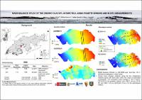
Mass balance study of the Znosko glacier, Antarctica, using remote sensing and in situ measurements
| dc.contributor.author | Bello, Cinthya | |
| dc.contributor.author | Suarez, Wilson | |
| dc.contributor.author | Brondi, F. | |
| dc.contributor.author | Gonzales, Gilbert | |
| dc.date.accessioned | 2022-04-04T18:55:26Z | |
| dc.date.available | 2022-04-04T18:55:26Z | |
| dc.date.issued | 2021-03 | |
| dc.identifier.uri | https://hdl.handle.net/20.500.12542/1900 | |
| dc.description.abstract | Glaciers are a key indicator of climate change. Since the second half of the 20th century several glaciers in Antarctica have retreated. In situ measurements of glacier mass balance in the Antarctic Peninsula and its surrounding islands are very scarce because this area is inaccessible due to rough terrain and inhospitable atmospheric conditions, but there is a necessity in study peripheral glaciers dynamics to know their future contribution to sea level rise. To fill this gap, remote sensing is an alternative tool to enable timely monitoring of dynamic glaciers and quantifying spatial-temporal changes. Here we combine remote sensing (satellite imaginary and aerial photos) and in situ measurements to calculate mass balance for the Znosko glacier (King George Island, Antarctic Peninsula) and compare the accuracy of this methods. Two field campaigns were carried out during the XXVI and XXVII Peruvian Antarctic Operation (austral summer 2018/19 and 2019/20). 19 stakes were fixed on the glacier surface, in situ mass balance data were collected from yearly stake measurements. Also, digital elevation models were generated through aerial photogrammetry and auxiliary data from the ICESat-2 mission were included into the analysis. We find that mass balances estimated with these methods are consistent and confirm the mass loss (heterogeneous pattern between accumulation and ablation zone) and retreat of Znosko glacier. We illustrate how participatory mapping (interdisciplinary team) can complement initial remote sensing land cover classification and assist ground checks. | es_PE |
| dc.format | application/pdf | es_PE |
| dc.language.iso | spa | es_PE |
| dc.publisher | European Geosciences Union | es_PE |
| dc.rights | info:eu-repo/semantics/openAccess | es_PE |
| dc.rights | Atribución-NoComercial-SinDerivadas 3.0 Estados Unidos de América | * |
| dc.rights.uri | http://creativecommons.org/licenses/by-nc-nd/3.0/us/ | * |
| dc.source | Repositorio Institucional - SENAMHI | es_PE |
| dc.source | Servicio Nacional de Meteorología e Hidrología del Perú | es_PE |
| dc.subject | Glaciares | es_PE |
| dc.subject | Antarctica | es_PE |
| dc.subject | Glaciar Znosko | es_PE |
| dc.title | Mass balance study of the Znosko glacier, Antarctica, using remote sensing and in situ measurements | es_PE |
| dc.type | info:eu-repo/semantics/report | es_PE |
| dc.subject.ocde | https://purl.org/pe-repo/ocde/ford#1.05.11 | es_PE |
| dc.publisher.country | PE | es_PE |
| dc.subject.sinia | temperatura - Clima y Eventos Naturales | |
| dc.type.sinia | text/libro.presentacion | |
| dc.identifier.url | https://hdl.handle.net/20.500.12542/1900 |
Ficheros en el ítem

Este ítem aparece en la(s) siguiente(s) colección(es)
-
Congreso [32]

Excepto si se señala otra cosa, la licencia del ítem se describe como info:eu-repo/semantics/openAccess