


Buscar
Climate change impacts on biomes and aridity in Peru
(European Geosciences Union, 2020-06-12)
The preliminary results showed that random forest worked best for the PB imbalanced data, having a 0.84 weighted average in precision and recall metric. The model reproduces 9 of the PB with low error 4.5% and overestimates ...
Acceso abierto

Analysis of remote sensing and in situ datasets to estimate spatial precipitation in high mountain areas: case study Cordillera Blanca, Peru
(European Geosciences Union, 2021-01)
This study focused on estimating precipitation for the Santa basin located north of the capital of Peru, assessing spatial patterns and temporal variation. Precipitation products were used at a daily temporal resolution ...
Acceso abierto
Using open source & low cost rain gauges to support debris flow real-time monitoring in Lima, Peru
(European Geosciences Union, 2021-01)
Debris flow, locally known as huaycos, impact the east part of the metropolitan city of Lima, capital of Peru. However, after many extreme events such as the one related to the 2017 “Coastal Niño” or the one in 1987, there ...
Acceso abierto
The vulnerability of water availability in Peru due to climate change: A probabilistic Budyko analysis
(European Geosciences Union, 2020)
This study provides for the-first-time a water availability analysis at drainage and basin-scale in Peru. Using new gridded datasets of precipitation and temperature, along with six global actual evapotranspiration estimations ...
Acceso abierto
Monthly semi-distributed hydrological model at national scale in Peru
(European Geosciences Union, 2020)
Surface water resources in Peru are heterogeneously distributed in three drainage areas (Pacific, Titicaca, and Atlantic), and their quantification is relevant for planning in economic activities such as water supply and ...
Acceso abierto
Surface water resources assessment in Peru through SWAT hydrological model
(European Geosciences Union, 2020)
Surface water resources in Peru show high spatio-temporal variability, being the prediction of streamflow at ungauged sites, one of the fundamental challenges today. This research presents a methodology for regional ...
Acceso abierto
Mass balance study of the Znosko glacier, Antarctica, using remote sensing and in situ measurements
(European Geosciences Union, 2021-03)
Glaciers are a key indicator of climate change. Since the second half of the 20th century several glaciers in Antarctica have retreated. In situ measurements of glacier mass balance in the Antarctic Peninsula and its ...
Acceso abierto
Influence of Climate Variability in King George Island Glacier Retreat – Antarctic Peninsula
(European Geosciences Union, 2021)
This research aims to explain the influence of climatic variables (temperature and precipitation) in King George Island (KGI) glacier shrinkage on the Antarctic Peninsula. It employed Landsat satellite images from 1989 to ...
Acceso abierto
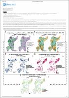
Studying spatial agreement of catchment response to climate and landuse change under uncertainty for prioritizing investment into hydropower catchments
(European Geosciences Union, 2022-04)
Joint climate and land cover change can significantly alter catchment hydrologic response, e.g., in terms of runoff and sediment delivery, and thus key determinants for downstream hydropower outcomes. While many studies ...
Acceso abierto
The Relationship Between Shallap Glacier - Cordillera Blanca and King George Island - Antarctic Peninsula
(American Geophysical Union, 2021-12)
The main goal of this study is to determine the relationship between Shallap Glacier (SG) — Cordillera Blanca and King George Island (KGI) glaciers — Antarctic Peninsula and describe their features. Multi-temporal analysis ...
Acceso abierto